 |
| Emerson Photos Courtesy of Digital Commonwealth/ Longmeadow Historical Society |
Looking back to snow covered roads and beautiful views of winters in Longmeadow, MA. These scenic photographs were taken more than 100 years ago!

This history blog includes photos, maps and articles about the people, places and things of Longmeadow, Massachusetts during the mid-19th and early 20th century.
|
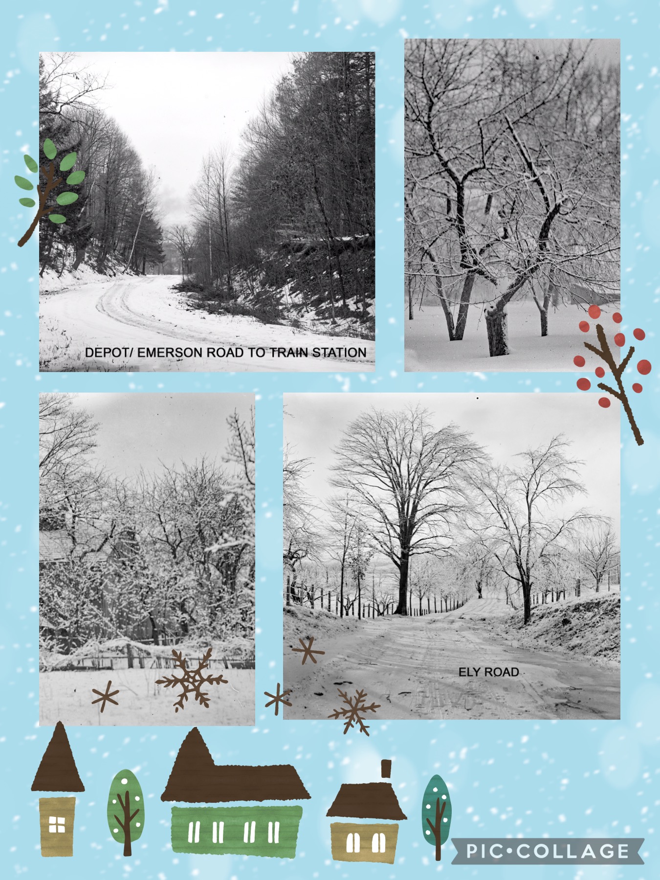
| Emerson Photos Courtesy of Digital Commonwealth/ Longmeadow Historical Society |
Looking back to snow covered roads and beautiful views of winters in Longmeadow, MA. These scenic photographs were taken more than 100 years ago!
On June 10, 1914 the Massachusetts Governor David I. Walsh signed the Bill that changed the boundary of Longmeadow, MA. Franconia had been a little hamlet that had been located in the northeast corner of Longmeadow. As of that day in June Franconia became part of Springfield, MA.
 | ||
| Springfield Union June 10, 1914 (Click to enlarge.) |
 | |
| Longmeadow School Committee Report 1894-1895 (Click to enlarge) |
 |
| Springfield Republican Jan. 23, 1914 (Click to enlarge.) |
Attorney John Aldrich represented the Franconia residents when they petitioned the State Legislature to become part of Springfield, MA. The Bill was passed and Gov. David I. Walsh signed it on June 10, 1914. According to the 1915 Longmeadow Annual Town Report there were 802 acres of land and about 33 houses in Franconia when the separation took place
 |
| 1915 Longmeadow Annual Town Report |
Shown below is a 1920 map of Longmeadow/ Springfield showing the section of Longmeadow (Franconia) that became part of Springfield in 1914.
 | ||||
| 1920 Map of Longmeadow/ Springfield Franconia section is outlined in yellow (Click map to enlarge) |
Written by Judy and Jim Moran
| This pivotal Special Town Meeting was held 5 years ago today January 25, 2018. |
 |
| click to enlarge |
The Brewer-Young Mansion at 734 Longmeadow Street was built in 1885 and is an iconic, historic landmark in Longmeadow. This 10,900 sq. ft. mansion was put on the market in 2010, but there was no interest from any residential buyers. The prior owner was foreclosed upon and evicted in 2015, and the mansion had fallen into severe disrepair. The mansion was considered too large and too costly to restore and maintain for it to ever be a private residence again. Restoring it would cost more than $2 million.
The Longmeadow Historic Preservation Partners (LHPP) led by town residents Dr. Andrew Lam and Chris Orszulak and local general contractor Henry Clement purchased this property in September 2017. The deterioration of this structure had reached a point that they needed to act soon if the historic mansion was to be saved.
The LHPP believed that the only way to save it was to make it self-sustaining. After analyzing all possible uses, they determined adaptive re-use as professional offices would be the most stable, sustainable way to preserve the mansion long-term. This use would also be least impactful to the Town Green and is one that can be supported by abutting homeowners.
The LHPP believed that saving this mansion would preserve and enhance Longmeadow’s historic character and the Town Green. They planned to restore the exterior to its former grand appearance and preserve most of the historic interior as well.
One key hurdle was the rezoning of this property for professional offices only, not commercial, so it could never become a retail store, restaurant, or anything else. This change would require a 2/3 vote at a Special Town Meeting in order to move forward.
This pivotal Special Town Meeting was held 5 years ago today on January 25, 2018.
Below is a photo of this Special Town Meeting with Dr. Andrew Lam outlining the plans before a packed Longmeadow High School gymnasium of some 1,250 Longmeadow voters.
In the weeks leading up to this STM there was significant opposition to this plan particularly by some owners living on the perimeter of the Town Green. In the end the zoning change from Residential A-1 to Professional District passed by ahttps://gofund.me/8663ddc3 narrow margin of 857-381 (2/3 approval vote required).
 |
| Dr. Andrew Lam Outlining Plans for the B-Y Mansion [click image to enlarge] |

Today,
the Brewer-Young Mansion at 734 Longmeadow Street is a vibrant building
with many small businesses and entrepreneurs as well as a medical
practice occupying the building. The exterior as well as the
interior of the structure have been completely renovated including
restoration and preservation of many architectural and esthetic
features.
For additional information including many photos about this project visit the Save the Mansion Facebook page.
Below are some exterior photos of the mansion during the past 100+ years.
 |
| [click to enlarge photo] |
 |
| [click to enlarge photo] |
 |
| [click image to enlarge] |
 |
| [click to enlarge photo] |
A huge THANK YOU to the Longmeadow Historic Preservation Partners who have certainly delivered on their promise to rejuvenate the Brewer-Young Mansion (both inside and outside) and have returned it to its status as a historic gem on the Longmeadow Town Green.
by Jim Moran/ Guest Historian
You may have guessed from the title of this blog post that the subject was related to the town of Enfield, Massachusetts in Hampshire County that disappeared as a result of the creation of the Quabbin Reservoir... but guess again. It turns out that the first Enfield, Massachusetts was Longmeadow's neighbor to the south which is now called Enfield, Connecticut.
 | ||
| 1785 map section [click image to enlarge] | |
The boundary of Massachusetts and Connecticut was disputed for many years and was caused by a surveying error in 1642 by Woodard and Saffery- two Boston surveyors who were commissioned by the Colony of Massachusetts. Their survey showed that the town of Enfield and other nearby towns were within the colony of Massachusetts. At that time Connecticut was seeking a charter from the King of England and Massachusetts decided it was wise to survey its southern border. A second 1695 survey by Butler and Whitney commissioned by Connecticut corrected the error and it showed that Enfield, as well as Suffield and Woodstock were within the borders of the Connecticut Colony (see 1713 survey map below).
 |
| 1713 Map Details 1642 survey and 1695 corrected MA/CT Border [click image to enlarge] |
In 1713 there was an agreement between the two colonies that allowed Massachusetts to continue governing the towns as defined by the 1642 survey even though it was recognized that there was a significant boundary error.
"By the agreement Massachusetts was as before to have jurisdiction over her old border towns, though they fell to the south of the new Colony line. For this privilege of jurisdiction Massachusetts agreed to compensate Connecticut. For as much territory as Massachusetts governed south of the true line, she agreed to give the same amount of territory to Connecticut in unimproved lands in Western Massachusetts." [The Boundary Disputes of Connecticut Chapter II, page 58]
Despite this 1713 agreement between the two colonies, the border dispute continued and was not fully resolved until 1804- a total of 162 years from the original 1642 survey.
Here is a 1774 map that showed the towns of Suffield and Enfield were included in the Colony of Massachusetts.
 | |
| 1774- Thomas Jefferys- Geographer [click image to enlarge] |
Another map- a 1785 post-Revolutionary War map of Massachusetts and Connecticut showed similar information. The towns of Enfield and Suffield were both located in the state of Massachusetts.
 | ||||||
| 1785 Map of MA/ CT/ Surveys by Holland, Evans and others Source: Massachusetts State Archives [click image to enlarge] |
| ||
| Enlargement of the 1785 map | |
While researching this subject I found an interesting book related to this subject.... The Boundary Disputes of Connecticut by Clarence Winthrop Bowen- published in 1882. In Part III/ Chapter 3 of this book, entitled The Controversy Concerning Woodstock, Enfield and Suffield there are some notable comments....
Another map of Longmeadow was created in 1794-5. It was part of a state mandated survey that was required of each town in Massachusetts by the state
legislature.
"For the compilation of a state map, each town in
Massachusetts (including those in the five eastern counties now part of
Maine) was required by Resolves 1794, May Sess, c 101 to make a town
plan based on a survey no more than seven years old, to be submitted to
the state secretary's office. Rivers, county roads, bridges,
courthouses, places of public worship, and distances of the town center
to the county shire town and to Boston were to be included."
Here is the 1795 map submitted by the town of Longmeadow to the state which has been annotated for clarity that showed Enfield to be well within the borders of the state of Massachusetts.
 |
| 1795 Map of Longmeadow [click image to enlarge] |
 | |
| 1802 Map of Massachusetts [click to enlarge] |
 | ||
| 1802 Map- enlarged section of Enfield/ Longmeadow | |
This 1802 map was the first time that Massachusetts had acknowledged that Enfield was in the state of Connecticut and not Massachusetts.
In 1804 the border dispute involving the towns of Enfield and Suffield was finally resolved and agreed upon by both states- Massachusetts and Connecticut ending the 162 year old border dispute.
For those who are reading this post and are interested in the history of Enfield, Massachusetts located in Hampshire county, here are some specifics...
References
In addition, the assistance of William Fournier and Robert Ellis- members of the Enfield Historical Society are gratefully acknowledged for their contributions to this article.
by Jim Moran/ Guest Historian
 |
| Unidentified trolly Date: ~ 1905 |

At first reports had come in that broken wires affected 3 trollys. One was located on the Liberty Street line in Springfield and another was on Springfield's Sumner Avenue line. The third was on the Longmeadow line and this trolly was stuck on Pecowsic Hill. Then 2 more trollys were affected in Longmeadow. One trolly was located near the home of E. S. Brewer on Longmeadow Street (on the Town Green). The second trolly was "in one of the gullies" in the southern part of town. Then, more reports came in about broken wires in Springfield.
 |
| Source: Springfield Daily Republican Jan. 12, 1903 |
 |
| Source: Springfield Daily Republican Jan. 12, 1903 |
Source: Springfield Daily Republican- Jan. 12, 1903.
~Written by Judy Moran
 |
| Springfield Republican December 25, 1949 |
On New Year's Day in 1950 Longmeadow, MA residents and also residents in the area enjoyed their opportunity to have dinner at the Old House on the Green! This restaurant was located at 797 Longmeadow Street in Longmeadow. It was a favorite establishment for many organizations and also for family celebrations. George E. and Margaret Adams were the proprietors of this restaurant that was located in a historic house on Longmeadow's Town Green.
 |
| 797 Longmeadow Street Date: 1909 Courtesy of Digital Commonwealth/ Longmeadow Historical Society |
Click here for a previously written post to learn more about this historic home that became a destination restaurant for many years.
It is now the year 2023!
I wish you all a Happy and a Healthy New Year!!
~Written by Judy Moran
 |
| Harry E. Bisco- December 1905 Photo colorized by Longmeadow Historian courtesy of Digital Commonwealth/ Longmeadow Historical Society (Click photo to enlarge.) |
In 1907 the Spencer, MA resident Paesiello Emerson moved to Longmeadow, MA. Many of us recognize his name. He was the gentleman who took up the hobby of photography later in his life. Mr. Emerson took photographs of people, places and objects in Longmeadow, MA- documenting our town at the turn of the 20th century.
Before moving to Longmeadow, Mr. Emerson enjoyed using his camera and took photos in the town where he lived, Spencer, MA. The photograph above was taken in Spencer in 1905. It is very interesting to see a young boy standing next to an early 20th century Christmas tree. We have the opportunity to view decorations on the tree and also gifts that he enjoyed. Strands of popcorn decorate the tree along with treasured manufactured ornaments and other keepsakes.
The boy is 6 year old Harry Evelith Bisco. He was born in Spencer, MA in 1899. Harry's father Leonard was a farmer in Spencer where Harry, his dad and his mom Nellie lived.
Perhaps this was a Christmas keepsake photo that Mr. and Mrs. Bisco paid Mr. Emerson to take. Or maybe it was a gift from Mr. Emerson to Harry's parents. Harry's name (first name misspelled) and the date is written on a sign under the tree.
This 1905 photograph gives us a wonderful opportunity to view a Christmas tree from 117 years ago!
Paesiello Emerson took another photo also dated December 1905. It was a photo of the Bisco family.
 | |
| Bisco Family- December 1905 Photo colorized by Longmeadow Historian courtesy of Digital Commonwealth/ Longmeadow Historical Society (Click photo enlarge.) | |
Thank you Mr. Emerson for taking these interesting photographs 117 years ago!
Sources: 1899 Spencer, MA Marriage Records, 1899 Spencer, MA Birth Records, Springfield Republican- May 15, 1907, 1880, 1900 and 1910 U.S. Federal Census, 1903-04 Spencer, MA Marriage Records and 1907 Spencer, MA Street Directory.
~Written by Judy Moran